Solomon Islands
Things to DO
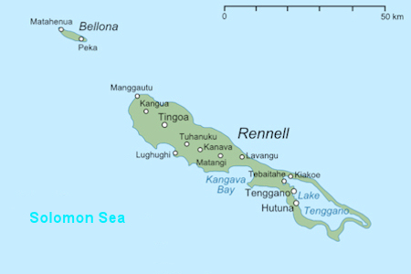
Rennel Island
Rennell and Bellona are both Polynesian-inhabited islands within the predominantly Melanesian Solomons. They are
thus considered Polynesian outliers. (culturally Polynesian societies that geographically lie outside the main region
of Polynesian influence)
The first known European to sight the islands was Mathew Boyd of Camberwell, London, commander of the merchant ship,
Bellona, in 1793. Rennell Island may have been named for the oceanographer James Rennell (1742–1830).
The names the islanders used for self-reference are "Mungiki" (Bellona) and "Mungava" (Rennell), meaning small
mountain and large island respectively.
According to oral traditions, the islands were originally inhabited by a people of another culture before the ancestors of
present-day Polynesians arrived in canoes from their homeland, "Uvea Gago" (probably Ouvéa in the Loyalty Islands,
New Caledonia). The oral traditions of Rennell and Bellona relate that the first invaders consisted of seven married couples
who each founded a clan ("sa’a"), of which five became extinct. Ancestors of the two remaining clans, Kaitu’u
and Iho, still inhabit the islands.
Initially, the two islands were contacted only sporadically by Europeans and Americans up to the later part of the nineteenth
century. In 1938, the Seventh Day Adventist Church became dominant on Rennell, followed by Bellona, which gradually
converted all the inhabitants to Christianity. They destroyed all their heathen temples and built Christian churches all over
the Islands.
Not until after World War II (1945) did Westernization slowly influenced the two islands. A closer contact with the rest of
the Solomon Islands sped up the modernization process. More regular shipping was initiated, and children were sent to mission
schools on other islands. In the 1950s health clinics and wireless contact were established on both islands. Regular air service
to both islands was established in the beginning of the 1970s.
 |
|||||
East Rennell, designated as a World Heritage Site in 1998, is at the southern end of the island; the site
includes Lake Tegano, the land surrounding it, and the marine areas stretching for three nautical miles from the island.
Lake Tegano (also known as Te Nggano), which was at one time the atoll's lagoon; the surface of the lake is at sea level and the
water is brackish. It is surrounded by cliffs and contains a number of small limestone islands.
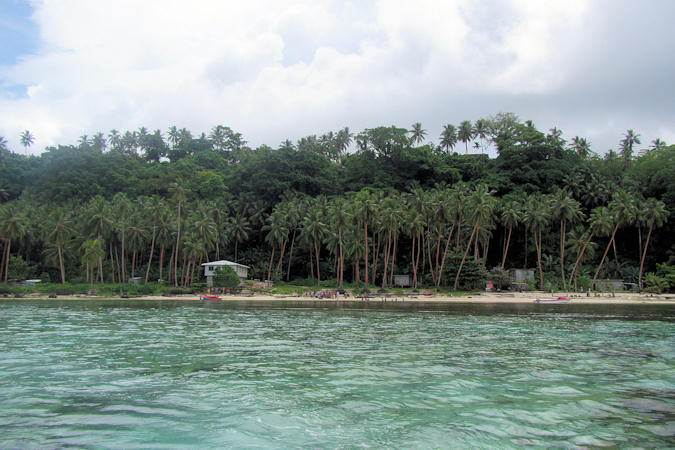
The island is covered with dense forest which provides habitat for the many bird species. It is logging in the west end of the
island, outside the site area, which is threatening the bird population of the whole island by depleting the areas of the forest
they need. As a result, in 2013, UNESCO added East Rennell to its List of World Heritage in Danger.
Fifty species of bird have been recorded on the island, twenty-one of these being endemic.
These are pictures
of the nature of Rennel Island.
Guadalcanal

 |
|||||
Guadalcanal's discovery by westerners was under the Spanish expedition of Álvaro de Mendaña de Neira in 1568.
The name comes from the village of Guadalcanal, in the province of Seville, Spain, birthplace of Pedro de Ortega Valencia,
a member of Mendaña's expedition.
During 1942–43, it was the scene of the Guadalcanal Campaign and saw bitter fighting between Japanese and US troops. The
Americans were ultimately victorious.
At the end of World War II, Honiara, on the north coast of Guadalcanal, became the new capital of the British Solomon
Islands Protectorate.
Just over a decade ago it was little more than a sleepy South Seas port, but over the last few years it has undergone an urban boom,
and traffic snarlups at peak hours are now increasingly common in the centre.
 |
|||||
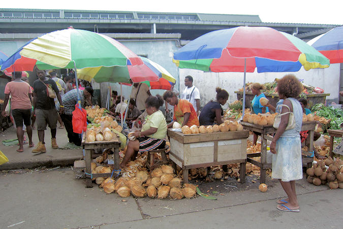
It's rarely love at first sight - the architecture wins no prizes and sights are sparse. But get under the
city's skin and the place just might start to grow on you.
The country's bubbling principal food market covers a whole block between Medana Ave and the seafront.
It has a huge selection of fresh produce, especially fruits and vegetables, that come from outlying villages along the northern
coast. Also on sale are traditional crafts. The fish market is at the back.
There's no hassling to buy anything, but beware of pickpockets.
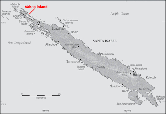
Vakao Island
The Mendaña expedition first sighted the island on 9 February 1568, naming it Santa Ysabel after the saint's day
on which they left Callao, Peru. Mendaña and his party spent some months on the island, building a small vessel to use to survey
and chart the surrounding sea and islands.
The Spanish immediately came into contact with Solomon Islanders and at first the relationship was cordial. However, the Spanish
expedition's need for fresh food and water quickly led to tension and conflict, the Solomon Islanders’ subsistence economy being unable
to provide continuous supplies to the Spanish.
Having found no gold and little food, and beset by attacks and sickness, the Spanish colonists shifted their colony to the site of
today's Honiara on Guadalcanal, and the settlement on Santa Isabel was abandoned.
In April 1885 a German Protectorate was declared over the North Solomon Islands, including Santa Isabel Island. In 1900, under
the terms of Treaty of Berlin (14 November 1899), Germany transferred the North Solomon Islands to the British Solomon Islands
Protectorate in exchange for the British giving up all claims to Samoa.
Missionaries settled on Santa Isabel Island under both protectorates, converting most of the population to Christianity.
In the early 20th century several British and Australian firms began large-scale coconut planting.
Vakao is one island of many in the North-Western part of Isabel Province
 |
|||||
and the area boasts breath-taking coral reefs, lagoons and forested islands. The small islands and the adjacent large island
of Baroro Faa represent one of the largest unlogged areas of the Solomons and this is reflected not only in the beautiful
virginforests, but in the quality of the sea water and the reefs.
Vavaghio Guest House was established on Vakao Island in 2013 and is the only residential property on the island. The local
Habotu family built the complex in 2012-13 to bring guests to share this wonderful part of the world they call “home”.
There are a variety of birds in the bush and on the shores of the island and surrounds, including many species of parrot and a
large population of the huge Hornbill.
The pristine reefs and warm, clear water make the area perfect for snorkelers.
This is a selection
of the nature i have seen there.
Kolombangara
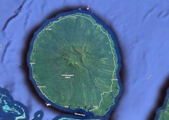
Kolombangara island is immediately appealing because the dormant volcano has a classic volcanic cone shape. The
cone rises from a circular 30km base to a crater rim 1.780m above sea level.
The last eruption was about 10,000 year ago and the cone has since heavily eroded, leaving a stunning shattered
crater, with a major gash in one side where the Vila River drains the crater centre.
The name is from a local language, a rough translation of its meaning is "Water Lord" with approximately 80 rivers and
streams running down its flanks.
 |
|||||
The indigenous people of Kolombangara, the Dughore people believe that all their ancestors came from a man and a
woman who lived inside the Kolombangara Crater, Kongu Rano.
Over time, the people moved out of the crater to live in villages further down the slope, in the major river valleys of the Vila,
Kukundu and Rei rivers. More recently, as the headhunting wars between islands stopped, the Kolombangara people settled
around the coast, leaving behind old village sites, burial places and other tambu sites in the mountains and the crater.
The most significant industry on the island is logging, principally based at Poitete.
The logging is restricted till 400m altitutre and the area above has been preserved from logging and is therefore home to dense
jungle with a large variety of wildlife